A new procedure to accurately define Nitrate Vulnerable Zones
The Nitrates Directive of the European Union (91/676/EEC) aims to reduce and prevent water pollution caused by nitrates from agricultural sources. It establishes that water resources should be considered polluted when nitrate concentration exceeds 50 mg L-1. The Directive requires the Member States to designate Nitrate Vulnerable Zones (NVZ), which are areas that drain into waters polluted or at risk of pollution by nitrates. In NVZ, farmers must follow mandatory measures within action programmes that include limiting N-fertilization and animal manure application to prevent nitrate leaching and runoff.
One of the difficulties in implementing the European environmental policies for nitrate pollution control is the lack of a common standard criterion for NVZ designation, which in turn may limit the success of action programmes in poorly defined NVZ. Index-based groundwater vulnerability mapping has proven to be a useful tool to assist governments in establishing policies related to the planning of water resource management over the last few decades. There are still, however, research gaps in assessment techniques and scientific considerations behind the inclusion/exclusion of parameters and their relative weights and ratings. In addition, most methods for mapping groundwater vulnerability are based on the excessively simplistic idea that aquifer recharge is only produced by vertical infiltration. The Land Use-Intrinsic Vulnerability (LU-IV) procedure for assessing groundwater vulnerability to nitrate pollution and delimiting NVZ was recently developed to address the above-stated challenges.
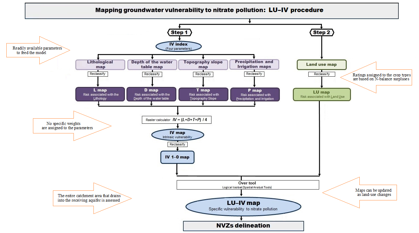
Fig. 1. LU-IV procedure for assessing groundwater vulnerability to nitrate pollution.
The LU-IV procedure (Fig. 1) combines a map of intrinsic vulnerability (IV map) and a map of the risk of N-loss associated with land use (LU map) by applying the Logical Math tools in ArcGIS to generate the map of vulnerability to nitrate pollution (LU-IV map). This methodology has the following distinctive characteristics: (1) it uses readily available parameters to feed the model, (2) it does not assign specific weights to the parameters, (3) it allows assessing the entire catchment area that drains into the aquifer, considering the solute transport through the aquifer catchment area, and (4) it permits periodical map updating as land-use changes over time.
The specific objective of this research was to conduct an empirical assessment of the risks of N-loss to groundwater associated with land use (LU) based on annual reports on the N-balance surplus in Spanish agriculture. These data were used to generate a detailed risk rating system reflecting the potential risks of N-loss by crop types. The new LU ratings were used to assess the specific vulnerability of groundwater to nitrate pollution by using the LU-IV procedure (Fig. 1). This fine-tuned model was compared with four other models for groundwater vulnerability assessment in which the LU ratings had not been empirically adjusted.
The study area to test the models included the catchment areas of 12 alluvial aquifers associated to tributaries of the River Ebro (Spain). Most of them were chronically polluted by nitrate, with only a few remaining unaffected by pollution. The potential NVZ were extracted from all the models for comparison with the map of groundwater nitrate content. Results confirmed that the LU-IV procedure using LU ratings from N-surpluses in crops was the best risk predictor of groundwater areas polluted by nitrate. These results support the high level of reliability of the LU-IV procedure for delimiting NVZ when applying the LU ratings obtained empirically from the N-surpluses.
Mercedes Arauzo 1, Gema García 1, María Valladolid 2
1Instituto de Ciencias Agrarias, Consejo Superior de Investigaciones Científicas (CSIC), Serrano 115 dpdo. 28006 Madrid, Spain
2Museo Nacional de Ciencias Naturales, Consejo Superior de Investigaciones Científicas (CSIC), José Gutiérrez Abascal 2, 28006 Madrid, Spain
Publication
Assessment of the risks of N-loss to groundwater from data on N-balance surplus in Spanish crops: An empirical basis to identify Nitrate Vulnerable Zones
Mercedes Arauzo, Gema García, María Valladolid
Sci Total Environ. 2019 Dec 15

Related Articles:
 | Can we accurately diagnose different clinical… Progressive Supranuclear Palsy (PSP) is the second most common degenerative parkinsonian syndrome after idiopathic Parkinson’s disease. PSP is a clinically heterogeneous disorder with several clinical variants. The two most common… |
 | Waking a sleeping giant: How increasing Africa's… Africa is home to 1.4 billion people, of whom 55 million suffer from cardiovascular disease (CVD). Despite this, Africa contributes to only 1.7% of the world’s cardiovascular science. We studied… |
 | Unlocking new treatments for bone diseases: using… Despite appearances, bones are a constantly changing organ in the body. Cells that produce new bone (named osteoblasts) and cells that break down bone (named osteoclasts) work in harmony to… |
 | Rabbits with mammary carcinomas as a model for… Within a breeding colony of rabbits, the American pathologist Harry Greene (1904-1969) observed that mammary carcinomas were restricted to certain families. This is suggestive of a familiar predisposition as it… |
 | Could mometasone furoate be a viable glucocorticoid… Glucocorticoids are medications widely used to treat inflammation and allergies, and in contexts of immunosuppression such as after transplants. They are well-established and safe. The problem is that, when used… |
 | Improving assessment of arthritis models to better… Rheumatoid Arthritis (RA) is a common inflammatory disease that is characterized by swelling and tenderness of multiple joints. The resulting pain and joint stiffness cause disability for patients and treatment… |


Leave a Reply
You must be logged in to post a comment.